Metablue

data-driven COLLABORATION solution

metablue banner

    Overview

    MetaBlue

    Data-driven collaboration solution for E&P seismic projects.

    Take your survey planning and management to the next level.

    metablue overview 2

    Highlights

    MetaBlue_Generic


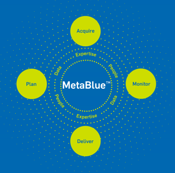
    From Silos to a Data-Driven Ecosystem

    MetaBlue is a digital collaboration solution that connects every stage of a seismic project, from planning to acquisition and data delivery, while monitoring survey progress in real-time.


    It is a game-changing solution that facilitates the involvement of all project stakeholders right from the beginning, leading to enhanced efficiency in survey planning and management, the delivery of high-quality data, and improved operational performance.
     

    Applications

    MetaBlue LAND

    Land seismic imaging presents considerable challenges, encompassing issues related to data quality and operational excellence. Lack of efficiency can affect the profitability of land seismic operations, with potential adverse impacts on safety and the environment if executed improperly.


    MetaBlue Land leverages Sercel's cutting-edge land software, unparalleled MEMS-based field unit technology, innovative land source solutions, and unique land acquisition services to seamlessly integrate data collection and optimize land survey outcomes.

    MetaBlue MARINE

    Operational silos in marine seismic acquisition impede collaboration and cause inefficiencies. Advanced solutions are required to break down these silos, improve safety, enhance data quality, and reduce environmental impact.

    MetaBlue Marine addresses these challenges by unifying acquisition data using Sercel’s market-leading marine software, MEMS-based nodal technology, towed streamer technology, innovative source solutions, and unique marine services, resulting in optimum survey outcomes.

    Key Benefits


    EFFICIENT OPERATIONS

    • Enhanced project turnaround times, increased productivity, and reduced costs.

    DATA QUALITY

    • Clearer and more accurate images of subsurface geological structures for informed exploration and drilling planning decisions.

    SUSTAINABILITY

    • Eco-conscious technologies, environmentally friendly operations, and improved safety.
    key benefits metablue 2

    Download

    Category Name Language Publication Size Download
    Brochure MetaBlue Marine Brochure (EN) English Jan 03, 2024 299.33 KB pdf
    Brochure MetaBlue Land Brochure (EN) English Jan 31, 2024 1.82 MB pdf